Regional Climate Adaptation Planning Guide

The 2020 California Adaptation Planning Guide 2.0 (APG) sets forth a detailed, four-phase process to help local governments, regional planning agencies, and tribal governments as they develop and integrate climate adaptation and resilience strategies. The Regional Resilience Framework (RRF) compliments the California Adaptation Planning Guide and provides localized guidance for SANDAG member agencies to help them build resilience to climate change hazards such as sea-level rise, extreme heat, wildfires, rain events, and other climate-related issues. Our Regional Climate Adaptation Planning Guide (below) is part of the RRF and is our localized version of the California APG.

At the beginning of the framework planning process, member agencies were surveyed and interviewed about the progress of their adaptation planning. Because there are numerous and often overlapping plans that can include adaptation components—such as stand-alone Climate Action Plans and/or Climate Adaptation Plans, Hazard Mitigation Plan updates, and General Plan updates—most jurisdictions found themselves in many different phases at once. Since hazards such as sea-level rise and wildfire have been at the forefront of regional planning for many years, jurisdictions are often in the later stages of addressing these hazards. In regard to emerging hazards such as extreme heat, jurisdictions are often in earlier stages.

To help member agencies understand their status in adaptation planning and what to do next, we’ve outlined each phase and its corollary steps below. The “Start Here” guide at the beginning of each phase includes considerations for each hazard. If your situation matches the status description in the “Start Here” guide, you’ve found the appropriate place to begin.

These assessments can be repeated over time as plans are adopted, implemented, and updated.

Funding for this project was provided by a grant funded through Senate Bill 1, the Road Repair and Accountability Act of 2017, Caltrans Formula Funds Work Element 320170 and 3201701.

Graphic showing the four phases of regional adaptation planning.

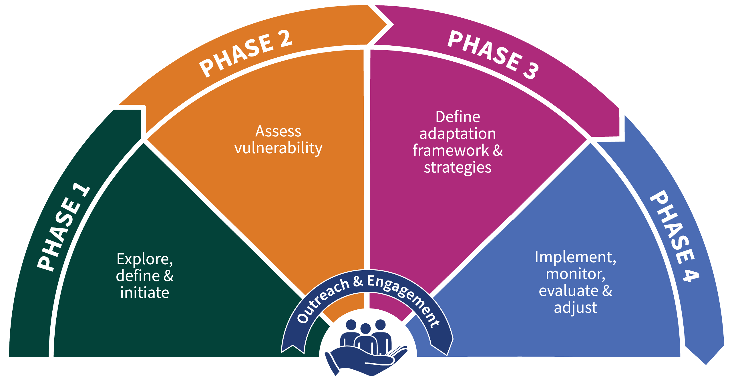
Regional adaptation planning consists of four phases. Assessments can be repeated over time as plans are adopted, implemented, and updated.

Phase 1: Explore, Define, and Initiate

If your situation matches this status description, you’ve found the appropriate place to begin.

  • Extreme heat: General Plan does NOT address SB 379 or SB 1000 (as applicable).
  • Wildfire: General Plan does NOT address SB 379, SB 99, Assembly Bill 1409, or SB 1000 (as applicable).
  • Inland flooding: General Plan does NOT address SB 379 or SB 1000 (as applicable).
  • Sea-level rise: LCP has not been updated to include sea-level rise.
Confirm the Planning Process, Purpose, and Outcomes

When starting to create or update a resilience plan, understand the legal requirements and community concerns you are trying to address. Outcomes will vary by plan. Compare your outcomes to the legal requirements outlined below. Local jurisdictions will also benefit from completing the Local Plan Alignment Worksheet (#3B) from Adapting to Rising Tides (ART)

Define Vision and Key Terms

Define the following terms if they are used. Example definitions are provided below.

  • Adaptation: The adjustment in natural or human systems in response to actual or expected climatic stimuli or their effects that moderates harm or exploits beneficial opportunities.[1]
  • Climate Equity: Involves addressing historical inequities suffered by people of color, allowing everyone to fairly share the same benefits and burdens from climate solutions and attain full and equal access to opportunities regardless of one’s background and identity.[2]
  • Mitigation: Strategies, policies, programs, actions, and activities that will serve to avoid, minimize, or compensate for the impacts to or disruption of elements of the human and natural environment over time.[3]
  • Preparation: Educational materials and training that will organize, equip, and train people to build and sustain the capabilities necessary to immediately respond to a hazard event, often before first responders can reach a majority of people affected.[4]
  • Recovery: Plans and standards for rebuilding to effectively recover after the danger has passed.
  • Resilience: The ability to prepare for changing conditions and withstand, respond to, and recover rapidly from disruptions and hazard events.
  • Response: Actions necessary to save lives, protect property and the environment, and meet basic human needs after an incident has occurred.
Map Project Boundary

Early in the planning process, it is crucial to understand where the plan is applicable. General Plans are applicable citywide, whereas Local Coastal Programs only apply in the coastal zone. Defining the area helps determine the hazards and populations that are included. 

Create a Timeline

Create a timeline to help set expectations for staff and community members who will be involved. Consider the following aspects when developing a timeline of events:

  • Staff capacity
  • Acquiring external support
  • Data availability
  • Community engagement
  • External review

These pre-planning stages are not always clearly outlined in a planning document.

Identify Capacity

A plan with clearly outlined partners indicated that this step has been achieved.

List Core Team Members

A plan with a range of agency and department representation and implementation indicates that this step has been achieved.

Inventory Technical Resources

A plan with clear data sources consistent with the APG indicates that this step has been achieved.

In the plan, outline historical hazard events and existing vulnerabilities. In Environmental Justice Elements, this also includes an assessment of how the built environment and past planning decisions have led to health inequities.

Integrate community outreach and engagement throughout the adaptation planning process to help inform the plan, build trust between the core planning team and community stakeholders, and build collective support for the plan. It is essential to enlist residents, businesses, students, and other community groups because they have knowledge, information, and ideas that local governments may not have or anticipate. Community members most affected by climate change can also collaborate on solutions, resulting in more effective implementation. Empowering community members to participate in the planning process is vital.

Stakeholder Mapping

Generate a broad list of stakeholders, including all residents. Define the role of each stakeholder group, including how, when, and where they should be engaged. Address access and language needs at this stage.

Creating Outreach Activities

Building on the stakeholder mapping, develop outreach activities that reflect the progression of the project/plan. Identify stakeholder groups that will participate in each activity, along with the method of data collection (e.g., meeting, survey) and how that data will inform the development of the plan.

The SANDAG Equity-First Approach to Climate Adaptation guidance document provides a general framework and best practices for designing, planning, and implementing a climate adaptation process that supports equitable outcomes. The document identifies trends, assumptions, emerging practices, indicators, metrics, and implementation opportunities that operationalize the equitable climate adaptation planning process. Furthermore, the Equity-First Approach to Climate Adaptation guidance connects to all Phases of the APG and adds an additional Phase 0— “Equity-First Stage”— which provides foundational knowledge and outlines the tools needed to create an equitable adaptation planning process.

Phase 2: Assess Vulnerability

If your situation matches this status description, you’ve found the appropriate place to begin.

  • Extreme heat: Planning team does not know the distribution of people sensitive to extreme heat, such as older adults, children, neighborhoods with older homes and those without air conditioning, and tree and park distribution.
  • Wildfire: Wildfire severity zone maps have not been updated with the most recent CAL FIRE data. Evacuation routes and communities with only one evacuation route have not been identified.
  • Inland flooding: Flooding maps have not been updated with the most recent FEMA data. The planning team does not know the distribution of renters.
  • Sea-level rise: Sea-Level Rise Vulnerability Assessment has not been completed.
List Climate Change Hazards

Accompany each identified hazard with a description outlining who and where the hazard would impact. Include forecasted change based on the best available data.

Map Hazards

Use a series of maps to show hazardous areas. This can be based on data from state agencies, past events, or specific studies.

Select Populations and Assets

Identify population groups that are especially vulnerable to each potential climate hazard. Map them when feasible. Cross-reference sensitive populations with the hazards identified in the previous phase of the vulnerability assessment. 

Similarly, critical assets (such as cellular communication and public utilities) and physical structures (such as fire stations and hospitals) should be identified.

Identify Intersections of Hazards, People, and the Built Environment

Map populations and assets and compare that information to the mapped hazards to determine if programs and/or policies are needed to preserve the services provided to the community by the critical assets.

Document Review

Outline how the plan relates to and is consistent with other community plans and priorities.

Agency and Stakeholder Interviews

Outline the role of outside agency staff in preparing for and responding to climate change.

Summarize Vulnerability

Clearly indicate complete findings and an outline of the priorities of the plan. 

Score Vulnerability

Include an assessment of how much damage a hazard poses and how well-prepared a community is to cope with that hazard in Hazard Mitigation Plans (such as Safety Elements and Local Hazard Mitigation Plans).

Phase 3: Define Adaptation Framework and Strategies

If your situation matches this status description, you’ve found the appropriate place to begin.

  • Extreme heat: Planning team has not developed an implementation plan with measures to evaluate progress.
  • Wildfire: Planning team has not developed an implementation plan with measures to evaluate progress.
  • Inland flooding: Planning team has not developed an implementation plan with measures to evaluate progress.
  • Sea-level rise: Planning team has not developed an implementation plan with a monitoring program to evaluate and modify strategies as needed.
Write Problem Statement

For each hazard, write a clear and concise problem statement in plain English to help stakeholders and the public understand the challenges without getting into the technical specifics. 

c studies.

Write Vision Goals and Objectives

For each hazard, include a goal (or multiple goals) that describes the future vision. These are often enumerated.

Select Adaptation Strategies

For each goal, include multiple adaptation strategies that outline how that vision will be achieved. A successful adaptation strategy includes:

  • Who is responsible for implementation
  • How will it be achieved
  • How will it be assessed
  • What is needed to accomplish it
  • When will it be accomplished
  • How will it be funded

Mirror the format and specifications of the strategies to match the document in which the adaptation policy framework is contained. For example, Safety Elements and Hazard Mitigation Plans may have their own style and format that is different from other planning documents.

Prioritize Adaptation Strategies

Outline how the chosen strategies were determined and their co-benefits.

SANDAG has created a climate adaptation strategy prioritization methodology and tool for jurisdictions within San Diego County. The tool uses a multicriteria, qualitative analytic approach. It provides insights into how communities and jurisdictions make strategic decisions when there are multiple objectives to consider and when the costs, benefits, or impacts are difficult to quantify. This method emphasizes criteria that reflect the three pillars of sustainability (equity, economy, and environment), in addition to feasibility and robustness.

Phase 4: Implement, Monitor, Evaluate, and Adjust

If your situation matches this status description, you’ve found the appropriate place to begin.

  • Extreme Heat: Planning team has not developed an implementation plan with measures to evaluate progress.
  • Wildfire: Planning team has not developed an implementation plan with measures to evaluate progress.
  • Inland Flooding: Planning team has not developed an implementation plan with measures to evaluate progress.
  • Sea-Level Rise: Planning team has not developed an implementation plan with a monitoring program to evaluate and modify strategies as needed.
Prepare Implementation Plan

Draft an implementation plan as part of a planning effort, or soon after a plan’s adoption. Implementation plans outline the government mechanisms used, including funding opportunities and partners. Implementation plans are detailed and include new programs, capital improvements, and municipal code changes.

Use a monitoring plan to track if the implementation plan was achieved, including if programs were funded or capital projects were built. For incentive-based implementation, track the change in development. Monitoring should measure local government actions and if the plan was implemented as envisioned.

Evaluate the intended community effect of a strategy. This could include public health metrics or the percentage of people living near community assets or in hazard areas. This evaluation happens well after a plan is implemented.

Adjust any strategy that was not as successful as intended. Similar to evaluation, this step often occurs years after a plan is adopted.

Local Adaptation Plans

Climate adaptation planning can be provided in many different planning documents. Learn more below, including any applicable legal requirements and how they can further adaptation planning.

What is it?

All cities and counties in California must have a General Plan. The General Plan is a blueprint for the future of the community and often has a 20-year planning horizon. Government Code Section 65302 requires every General Plan to contain seven elements, including a Safety Element. The Safety Element of a General Plan is a high-level document that identifies and examines current local hazards and provides policy to make the community less vulnerable to these threats. These hazards may include flooding, earthquakes, landslides, tsunamis, wildfires, hazardous waste, and more.

What are the legal requirements?

SB379 requires Safety Elements to consider how climate change will impact the forecasted effects of natural disasters.[5] SB 379 mandated that local jurisdictions update their Safety Elements to discuss climate change adaptation by January 1, 2022. The Office of Planning and Research (OPR) recommends the Safety Element be updated regularly to ensure the climate change section is up to date with current data and analysis; however, there are no specific requirements. Furthermore, OPR suggests that updating the Safety Element concurrently with the Housing Element, every 5-8 years, is generally a reasonable time frame.

How does it connect to other plans?

The Safety Element is strongly correlated to the San Diego Multi-Jurisdictional Hazard Mitigation Plan (MJHMP) and provides a policy framework and background report to implement the emergency management and mitigation measures found in the MJHMP. The Safety Element more generally addresses risk to human life, property damage, and economic and social dislocation through land use policy over a longer time frame, while the MJHMP focuses on specific hazard events and proposes direct mitigation and response strategies. The Housing Element helps to guide where, and what type of, housing will be developed within a given jurisdiction. As the Land Use and Housing Elements are updated to reflect future growth of new neighborhoods, it is essential that the Safety Element reflects the risks to new developments.

Which phases does it cover?

Safety Elements usually address Phases 1–3 of the APG. As required by OPR, they must describe the risks and vulnerabilities a community faces, and create tailored goals, policies, and actions to address these specific needs. General Plans serve as high-level documents but may include detailed implementation programs addressing Phase 4.

What is the status of climate resilience in Safety Elements?

As of November 2022, 71% of jurisdictions in the SANDAG region have Safety Elements that include climate resilience or are in the process of updating their Safety Element.

What is it?

The Environmental Justice Element addresses the public health and safety needs of disadvantaged communities. This element reports on community conditions such as access to healthy food, local pollution exposure, and other environmental burdens including the effects of climate change and related hazards.

What are the legal requirements?

The Environmental Justice Element is a state requirement created through SB1000.[6] Only jurisdictions that contain disadvantaged communities (or neighborhoods in census tracts that score in the top 25% as compared to census tracts throughout the rest of the state) need to address environmental justice.[7] A jurisdiction must write an Environmental Justice Element when two or more General Plan elements are updated at the same time. In practice, these updates have been commonly adopted concurrently with Housing and Safety Elements.

How does it connect to other plans?

OPR recognizes that disadvantaged communities are often most vulnerable to the effects of climate change. For this reason, the Environmental Justice and Safety Elements coordinate to protect disadvantaged and vulnerable communities from climate change-related hazards.[8]

Which phases does it cover?

Environmental Justice Elements usually address Phases 1-4 of the APG. As required by OPR, they must identify objectives and policies to reduce health risks in disadvantaged communities, promote civic engagement in the public decision-making process, and prioritize improvements and programs that address the needs of disadvantaged communities.

What is the status of climate resilience in Environmental Justice Elements?

As of November 2022, Environmental Justice Elements in 43% of jurisdictions in the San Diego region include climate resilience or are in the process of being updated.

What is it?

A Climate Action Plan (CAP) is a document that inventories and strategizes the reduction of greenhouse gas (GHG) emissions over time through programs and policies.

What are the legal requirements?

CAPs are not required by the State of California; however, they are meant to help local governments meet California’s GHG mitigation goals and are often used to encourage the streamlining of the California Environmental Quality Act (CEQA).[9] For example, SB97 mandates that CEQA consider GHG impacts of a proposed project in CEQA analysis.[10] If a jurisdiction creates a CAP that plans for projected cumulative GHG impacts, then proposed projects under CEQA may be granted streamlining approval as long as the impacts are accounted for and consistent with the cumulative impact analysis in the CAP.[11]

How does it connect to other plans?

The CAP is aimed directly at addressing the causes of climate change. Although the policies to reduce GHG emissions may not directly address adaptation, CAPs are inherently connected to any climate-related policy. In many cases, the CAP will also contain climate adaptation measures.

Which phases does it cover?

CAPs usually address Phases 1-3 of the APG and can include aspects of Phase 4. Many CAPs and Climate Adaptation Plans contain background data and analysis, adaptation strategies, and often an implementation plan.

What is the status of climate resilience in Climate Action Plans?

As of November 2022, 93% of jurisdictions in the SANDAG region have either a CAP or Climate Adaptation Plan that includes climate resilience.

What is it?

A Climate Adaptation Plan is created to strategize how a jurisdiction will protect its property, maintain its community identity, and secure its quality of life over time as climate change-related hazards become more common and dangerous. The Climate Adaptation Plan discusses programs and policies to help the jurisdiction adapt to an inevitably new environment.

What are the legal requirements?

Stand-alone Climate Adaptation Plans are not required by law. Local governments may choose to adopt them to create a comprehensive plan that informs the General Plan, Local Coastal Plan, and Multi-Hazard Mitigation Plan.[12]

How does it connect to other plans?

The principal purpose of adaptation planning is to prepare for natural disasters and environmental harms, including extreme heat, sea-level rise, and other hazards that are influenced by climate change.

Which phases does it cover?

Climate Adaptation Plans usually address Phases 1-3 of the APG and can include aspects of Phase 4. Many Climate Adaptation Plans, as well as Climate Action Plans, contain background data and analysis, adaptation strategies, and often an implementation plan.

What is the status of climate resilience in Climate Adaptation Plans?

As of November 2022, 16% of jurisdictions in the SANDAG region have a stand-alone plan and an additional 47% include adaptation in a similar plan.

What is it?

Local Coastal Programs (LCPs) are basic planning tools used by local governments to guide development in the coastal zone in partnership with the California Coastal Commission. LCPs contain the ground rules for future development and protection of coastal resources. Each LCP includes a land use plan and measures to implement the plan (such as zoning ordinances). While each LCP reflects unique characteristics of individual coastal communities, regional and statewide interests and concerns must also be addressed in conformity with California Coastal Act goals and policies. Only jurisdictions with land within the coastal zone need an LCP.

What are the legal requirements?

The Coastal Act requires that local governments develop LCPs to carry out policies of the California Coastal Act at the local level. Once certified by the California Coastal Commission as consistent with and adequate to carry out the California Coastal Act, responsibility for issuance of most Coastal Development Permits under the certified LCP is delegated to the local government. The California Coastal Commission retains some continuing permit and appeal jurisdiction following LCP certification and responsibility to certify any amendments to the LCP.

How does it connect to other plans?

The LCP takes into account climate change-related coastal hazards (such as sea-level rise, tsunamis, coastal flooding, storm waves, landslides, and coastal bluff erosion) as they relate to existing land uses and planned development. While LCPs are only applicable in the coastal zone, they parallel Safety Elements and other General Plan components by regulating land uses. The California Coastal Commission adopted an Environmental Justice Policy in 2019 that addresses how to improve environmental justice and access, even if a disadvantaged community is not present in the area.

Which phases does it cover?

LCPs address Phases 1-4 of the APG. The California Coastal Commission’s Sea-Level Rise Policy Guidance provides a step-by-step process for addressing sea-level rise and adaptation planning in new and updated LCPs. These steps can be tailored to fit the needs of individual communities and address specific coastal resource and development issues, such as dealing with bluff erosion or providing for effective redevelopment, urban infill, and concentration of development in already developed areas.

What is the status of climate resilience in Local Coastal Programs?

As of November 2022, only the County of San Diego has an LCP that addresses climate change and has been adopted by the California Coastal Commission. Of the remaining coastal member agencies that have completed a vulnerability assessment, most have completed a Climate Adaptation Plan, and some are working through California Coastal Commission policy review.

What is it?

The Multi-Hazard Mitigation Plan (MHMP) is a San Diego County-wide plan that identifies risks and strategies to minimize damage from natural and human-caused disasters. It is a comprehensive resource document that intends to increase public awareness of hazards, create a decision tool for management, promote compliance with state and federal requirements, enhance local policies for hazard mitigation, and provide inter-jurisdictional coordination.[13]

The County of San Diego’s MHMP was last revised in 2018 and is currently undergoing a 2023 revision and public input process.

What are the legal requirements?

The Federal Disaster Mitigation Act of 2000 requires all local governments to create a Disaster Mitigation Plan to qualify for hazard mitigation funding. Section 322 sets requirements for mitigation planning at the state and local levels. Each local mitigation plan must:

  • Describe actions to mitigate hazards, risks, and vulnerabilities identified in the plan
  • Establish a strategy to implement those actions[14]

Moreover, local and tribal mitigation plans must demonstrate that proposed mitigation measures are based on a sound planning process that accounts for risks to and capabilities of individual communities.

How does it connect to other plans?

General Plan Safety Elements take hazard mitigation into consideration by discussing disaster preparedness (for natural and human-caused disasters), restoration of municipal services, and seismic safety. However, the MHMP has a greater level of detail and specificity regarding hazards, risks, and vulnerabilities, and sets out strategies for concrete mitigation actions.

What phases does it cover?

The MHMP addresses Phases 1-4 of the APG. It includes hazard identification; profiles of various hazards, including maps; vulnerability assessment, goals, objectives, and actions; and guidelines for monitoring, evaluating, and updating plans.

What is the status of climate resilience in the Multi-Hazard Mitigation Plan?

As a result of public input on the planning process, the upcoming revision of the MHMP will incorporate a section on climate mitigation, which was absent from the 2018 MHMP. The MHMP will specifically address climate resilience.

[1] SANDAG (San Diego Association of Governments). 2021. An Equity-First Approach to Climate Adaptation. Accessed December 30, 2022. https://sandag.org/-/media/SANDAG/Documents/PDF/projects-and-programs/environment/climate-resilience-and-adaptation/holistic-adaptation-planning/an-equity-first-approach-to-climate-adaptation-2021.pdf.

[2] City of San Diego. 2019. Climate Equity Index Report. https://www.sandiego.gov/sites/default/files/2019_climate_equity_index_report.pdf

[3] SANDAG. 2021. San Diego Forward 2021 Regional Plan. https://www.sandag.org/regional-plan.

[4] Federal Emergency Management Agency. 2013. Local Mitigation Planning Handbook. https://www.fema.gov/sites/default/files/2020-06/fema-local-mitigation-planning-handbook_03-2013.pdf.

[5] Jackson. 2015. Senate Bill No. 379. https://leginfo.legislature.ca.gov/faces/billTextClient.xhtml?bill_id=201520160SB379.

[6] Land Use: General Plans: Safety and Environmental Justice, S. 1000, September 24, 2016. https://leginfo.legislature.ca.gov/faces/billNavClient.xhtml?bill_id=201520160SB1000.

[7] California OPR. 2020. “General Plan Guidelines, Chapter 4.8: Environmental Justice Element.”

[8] California OPR 2020.

[9] Boswell, M., and M. Jacobson. 2019. 2019 Report on the State of Climate Action Plans in California. San Luis Obispo: California Polytechnic State University, City and Regional Planning Department.

[10] California OPR. 2008. Addressing Climate Change Through California Environmental Quality Act (CEQA) Review: Technical Advisory.

[11] Title 14 CCR 15183.5.

[12] California OES. 2020. California Adaptation Planning Guide.

[13] Office of Emergency Services and Unified Disaster Council, San Diego County. 2017. Multi-Jurisdictional Hazard Mitigation Plan. October 2017. https://www.sandiegocounty.gov/oes/emergency_management/oes_jl_mitplan.html.

[14] Public Law 106-390, 106th Congress, Disaster Mitigation Act of 2000. https://www.fema.gov/sites/default/files/2020-11/fema_disaster-mitigation-act-of-2000_10-30-2000.pdf.